


The Role of Drone Technology in Sustainable Agriculture
With the world supply at an all-time high and commodity prices at an all-time low as a result of increasing demands in food production and consumption, the modern farming industry is at a crossroads. There is a greater need than ever before for farmers and agronomists across the globe to improve resource management in response to tightening budgets, while the “farm to fork” movement has seen rising pressure for enhanced product traceability, as consumers become more interested in the origin of the goods they purchase and how they were grown.
Furthermore, climate change continues to create new layers of complexity for the agriculture industry in protecting the security of the supply chain. Rapidly evolving environmental conditions further exacerbate these challenges, and the latest figures show that the overall loss to agriculture across Europe from climate change could be as high as 16% by 2050. Indeed, optimizing sustainability credentials to minimize the impact on the health and well-being of the public and the planet will remain a priority, particularly as enhanced sustainability measures could also provide additional economic benefits by enabling agriculture professionals to focus their resources and efforts more effectively.
A landmark report published by the Intergovernmental Panel on Climate Change (IPCC) states that sustainable land management could be key to reversing the impact of climate change on land degradation – a significant consequence of human and agricultural activity and extreme weather conditions, in which the quality of land and soil is polluted or degraded. The report claims that this could provide “cost-effective, immediate and long-term benefits”. With this in mind, it is crucial that farms change how they operate to not only mitigate the effects of climate change, but to protect themselves against economic loss.
The Rise of Precision Agriculture
To balance feeding the planet with reducing global emissions, ambitious plans have been put in place. The U.K.’s National Farmers’ Union (NFU), for example, has outlined its goal of making British agriculture carbon neutral by 2040, with the introduction of a range of measures to improve land management, increase farming efficiencies, and boost the wider bioeconomy. Although there is no single answer to the problem, the NFU has advocated working “smarter” to cut direct pollution from farming, by delivering the same value with fewer emissions.
Precision agriculture practices, which can help farmers make better informed decisions, have evolved significantly over recent years, with the global market now estimated to reach $43.4 billion by 2025. While drones, also known as unmanned aerial vehicles (UAVs), have not yet made it into the mainstream agriculture space, they are playing an increasingly important role in precision farming, helping agriculture professionals lead the way with sustainable farming practices, while also protecting and increasing profitability.

The use of global positioning system (GPS) technology, together with geographic information system (GIS) tools, form a large part of these precision agriculture practices allowing fine-scale monitoring and mapping of yield and crop parameter data within fields. These provide more intense and efficient cultivation methods, which can help farmers adjust fertilizer prescriptions or identify crop diseases before they become widespread. With more data at their fingertips, farmers can make decisions based on economic and environmental factors – for example, by optimizing fertilizer treatment and applying only the right amount at the right time, significant cost and environmental savings can be made.
The Adoption of Drones
The use of drones in the agriculture industry is steadily growing as part of an effective approach to sustainable agricultural management that allows agronomists, agricultural engineers, and farmers to help streamline their operations, using robust data analytics to gain effective insights into their crops. Crop monitoring, for example, is made easier by using drone data to accurately plan and make ongoing improvements, such as the use of ditches and evolving fertilizer applications. Products can be accurately traced from farm to fork using GPS locations for every point in the journey, rather than more traditional time and labor-intensive data collection.
UAVs are particularly useful for the careful monitoring of large areas of farmland, considering factors such as slope and elevation, for example, to identify the most suitable seeding prescriptions. The technology has also proven useful in gaining an extensive overview of plant emergence and population, as more accurate data can help with replanting decisions, as well as thinning and pruning activity and the improvement of crop models.
Crucially, the high-resolution nature of drone data can be used to assess the fertility of crops, allowing agricultural professionals to more accurately apply fertilizer, reduce wastage, and plan – and troubleshoot – irrigation systems. The technology can also be particularly effective following natural disasters, such as a flood, to help farmers to assess damage across terrains that may not be readily accessible on foot.
Taking Drones Further
The potential for UAVs in the improvement of sustainable agriculture is huge. Already the agriculture drone market is predicted to be worth US$32.4 billion – an indication that the industry is beginning to recognize the benefits over more traditional methods, such as ground mapping.
Given the extensive terrain that requires surveying, drones offer increased efficiency, allowing users to capture high-resolution imagery more quickly than alternative methods. Particularly in these volatile market conditions, estimating annual yield can help guide decision-making and manage expectations. In addition, UAVs are now seen as a safer option for mapping difficult areas, such as uneven or expansive fields, that can be hazardous for operators – particularly compared to terrestrial techniques, which must be carried out on-foot.
Where satellites and manned aircrafts have traditionally been used to monitor agriculture, UAVs are quickly becoming recognized as a more accurate and cost-effective replacement. Studies have shown that drone imagery provides a higher rate of accuracy and resolution – even on cloudy days. While using traditional terrestrial approaches to collect data in challenging weather conditions could potentially delay projects for days, accurate crop health assessments can be made throughout the year using UAVs.
Related:
- How Satellite Monitoring Can Make Farming More Sustainable
- The Future of Satellites in Precision Agriculture
- Imagery in Agriculture: Time for a Reality Check
- A Realistic Look at UAVs and Aerial Application in Agriculture
The cameras on satellites and manned aircrafts have also historically been insufficient to map fields clearly, making it impossible to gain an exact picture of plants. In contrast, UAV technology provides users with an accurate picture of the different plant parts – even allowing the early identification of pests and diseases. Historically, processing these high-quality images took longer than ground mapping and satellite methods, however thanks to new software solutions, the processing time has been reduced to only a few minutes. This means it can be carried out while still in the field, allowing evidence-based decisions to be made immediately and data to be directly inputted into precision farming equipment, considerably speeding up the process.
Key Considerations
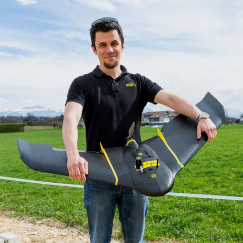
Once farmers have decided to employ drones in agricultural management, there are several factors to consider before investment. Rotary drones and fixed-wing drones are two types of UAVs that each bring distinct advantages. A rotary system, such as a quadcopter or multicopter, is ideal for mapping and inspecting small areas, thanks to its ability to take high resolution imagery at closer range, using mm per pixel. The take-off and landing area can also be very small, which suits more urban areas. In contrast, a fixed-wing drone is often more suitable and beneficial for agricultural applications, where mapped areas are usually large and take-off and landing space is not limited. Its endurance and high cruising speed allows a greater area of land to be mapped up to 2.6x faster, with an object resolution of cm/inch per pixel, and users also benefit from its ability to withstand high wind resistance – an important factor when mapping large areas of open land – as well as reduced labor costs.
In addition to the choice of device, agricultural professionals must also consider the benefits of using a third party to assist with flying the drones, or whether it is more beneficial to train a team in-house. Companies are increasingly opting to use drones in-house, due to the long-term cost benefits and potential return-on-investment. Advances in technology now means that UAVs can also be seamlessly integrated with existing farm management information systems (FMIS), to reduce time spent planning and in the field. Helping to streamline workflows further, partnerships between hardware and software manufacturers can also support agricultural professionals with the processing and analysis following data collection – all in one system.
This allows agricultural professionals to fly the drone and process the images using accompanying software, before exporting the data directly to an application map for use on farming equipment, such as sprayers. These measures enable precision application and ensure less wastage of materials, which can help save costs. Linking the farmer, drone maker, software, ag service provider, and agronomist together, this level of seamless integration enables a complete drone to tractor workflow – leading the way in intelligent agriculture and optimizing farm management methods.
It is also crucial for operators to keep up to date with regulations, such as controlled airspaces around airports and individuals’ privacy. Legislation is continuously evolving and is not currently harmonized across the world. Since regulations vary substantially between regions, having the right team in place can help drone operators in the agriculture industry choose a compliant model, ensure they have the correct certification and fly according to the latest guidance and safety and regulatory standards.
Flying High
With rising emissions from agriculture an increasing problem, changes in farming need to be made to help mitigate climate change and protect against future environmental impact. Agricultural mapping with drones has become more accessible, allowing operators to gain crucial insights into the health of crops and plan accordingly. Not only does the technology have a positive environmental impact, but it can also result in significant cost savings for farmers and agricultural professionals in the long-term. Drones have become an efficient way to quickly and easily map difficult terrain – particularly compared to more traditional methods of mapping, such as manned aircrafts and satellites. This is helping agriculture become a data-driven industry. Technology giant, Microsoft, is leading the way in this area with its Microsoft Azure FarmBeats program, using data analytics from UAVs to boost farm productivity and reduce resource usage.
The future for drone technology in improving sustainability is promising. The next step will be the use of artificial intelligence (AI) to automatically analyze the resulting data. Not only would this encourage more efficient operations but enabling more frequent health assessments would also help improve sustainability throughout the industry.
Case Study: Reducing Herbicide Use in Brazil
Drones have been used to help reduce herbicide use by 52% in a Brazilian soybean field. With a flight time of up to 90 minutes, the senseFly eBee X allows up to 500 hectares (1,200 acres) to be mapped, providing high quality images of fields. Accurate images of the landscape were processed and analyzed using xarvio FIELD MANAGER to automatically detect areas with weed infestation. The team quickly and efficiently gained access to the results and classification of weed infestation level within hours, with detailed accounts of weed thresholds. The results generated by the fleet of eBee X fixed-wing drones using xarvio FIELD MANAGER processing technology helped to generate herbicide application maps that saved, on average, 52% of herbicides for farmers in the 2018/19 season in Brazil.
Subscribe Today For
