


Drone Mapping With the John Deere Operations Center

We talked to Nick Guadagnoli, Technology Solutions Manager for 4Rivers Equipment in the U.S. about how they use the John Deere Operations Center in their everyday workflow.
4Rivers Equipment is a dealership that chooses the best suppliers from each solution category, such as John Deere, Wirtgen, Topcon, DJI, and Pix4D. “We offer sales, rental, service, parts, and training for the supplier’s product lines. The purchase of equipment is the first step but having a dealer there that offers superior aftermarket product support is key to the customer’s success,” Guadagnoli says.
Pix4D: What do you see as the main benefits of the Pix4Dfields and John Deere Operations Center integration?
Guadagnoli: For me as a dealer, having all Deere data as well as third-party data, like Pix4Dfields data, flow into one platform means I can focus my team of IS Solution Specialists on one product, rather than multiple products. Focus translates to much more highly skilled technical staff, rather than a staff that is “jack of all trades, master of none.”
MORE BY BARBARA HORVATIC
This translates into a much more satisfied customer because they can come to us with questions and feel certain that they’re receiving guidance from very technically competent individuals with the product they’re seeking advice on. From a customer point of view, growers usually don’t have the free time it takes to become experts with multiple different farm management software platforms. For them to be efficient and develop their skills as deeply as possible, having data aggregated in one platform like John Deere Operations Center, is critical. They can rely on 4Rivers Equipment and the Operations Center clinics we host throughout the year, to help them grow their own personal competency with the product.


Pix4D: Explain the connected digital agriculture workflow.
Guadagnoli: With the new Connect feature, data can flow smoothly from Pix4Dfields to the John Deere platform. Here’s how:
- Plan the mission with the customer, to be sure you are covering all areas of their fields.
- Fly the mission and capture the data.
- Transfer the data to Pix4Dfields and process the captured photos into an orthomosaic.
- Draw field boundaries, identify avoidance areas in the field and then work through the different indexes to generate zones within the fields.
- Connect the customer’s Pix4Dfields account to their John Deere Operations Center account, via the Export options in Pix4Dfields.
- Upload the zones from Pix4Dfields to their John Deere Operations Center account.
- Open the John Deere Operations Center and show the customer the zones transferred from Pix4Dfields. These zones can be used to create prescription files for application of different types of inputs like chemicals, fertilizers and so on.
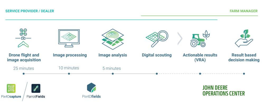
Drone to John Deere Operations Center workflow.
Drone Flight and Image Acquisition for Agriculture
Pix4D: What kind of drones and cameras do you recommend or use?
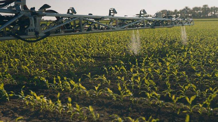
Guadagnoli: Recently for agriculture, the latest DJI P4 Multispectral.
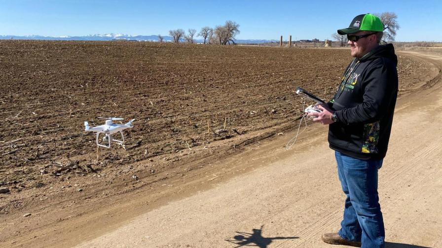
Capturing data with DJI P4 Multispectral.
Pix4D: Why is it important for you and your customers to fly a drone?
Guadagnoli: The value of the drone for our growers boils down to time. If we can save our growers 5 to 10 hours per week by capturing hundreds of acres of scouting data in minutes, instead of hours, we have added significant value. Less time in the field for our growers means more time at home in the evening with their families, attending more of their children’s extracurricular activities, and hopefully even a vacation or two away from the farm with their family.
Pix4D: How did your clients check their fields before choosing drone technology?
Guadagnoli: Traditionally a grower needed to drive to their fields and get out and walk the interior. Drones do not replace the need to walk to problem areas to identify specific issues, however, they do allow the grower to identify problem areas so their time in their field is very targeted toward the problem areas already identified.
Pix4D: What kind of data records did they have and how reliable was the information?
Guadagnoli: All this information was usually captured on paper. The issues identified by sight are very useful to the grower, however, the data is not easily shared with others that may work through their operation since it is one individual paper record. Having Pix4Dfields and John Deere Operations Center, this information can be shared digitally with their agronomist, custom applicators, retailers, state and federal agencies, insurance companies and their technology supplier.
In-field Image Processing and Analysis
Pix4D: How important is the speed of processing for you and your customers?
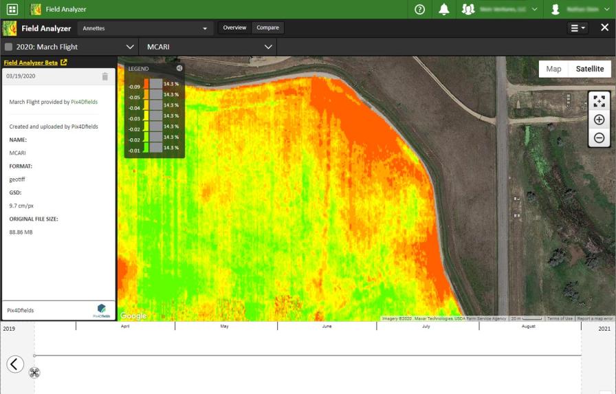
Guadagnoli: This is critical. Growers need access to the results of the mission at the field’s edge, they can’t afford to wait hours for data to process. In the time spent flying the drone, that grower may have gotten 10 phone calls that he needs to respond to. Adding value to that grower’s operation, in as short an amount of time as possible, is key.
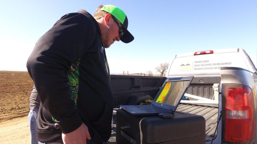
Get results without leaving the field.
Pix4D: What is the biggest value of having in-field processed data and analysis?
Guadagnoli: Data is available immediately which allows issues to be spotted at the field’s edge, and then the grower and their agronomist have targets to go directly to in their field to understand what the source of the issue may be. By their very nature, farms are typically in rural areas where cellular signals and internet speeds, in general, are not what they are in urban centers. Being able to work offline is crucial.
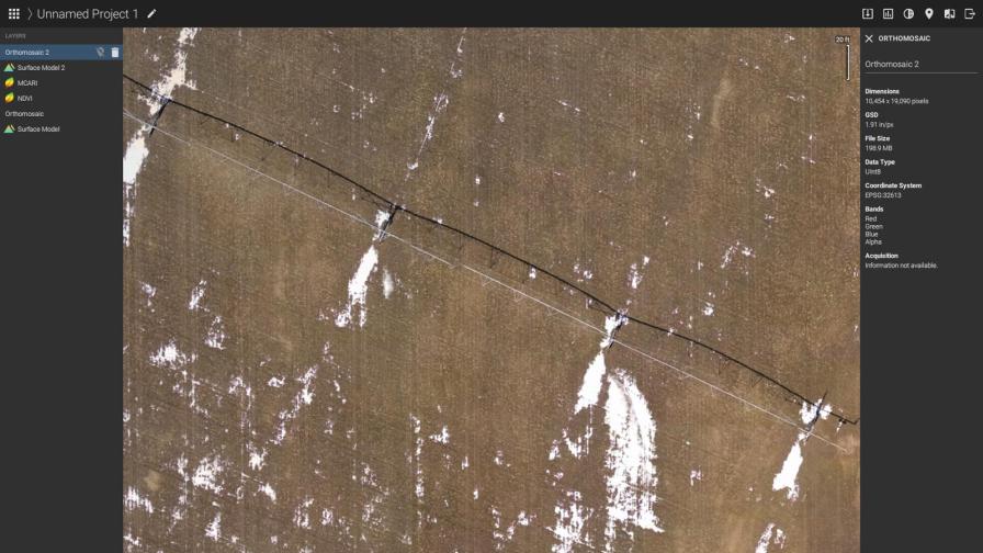
Checking the area of center pivot that irrigates the land.
Pix4D: How important is the calibration and accuracy of the results?
Guadagnoli: Accuracy, consistency, and reliability of the data are critical. If growers question the integrity of the data, they will not use it.
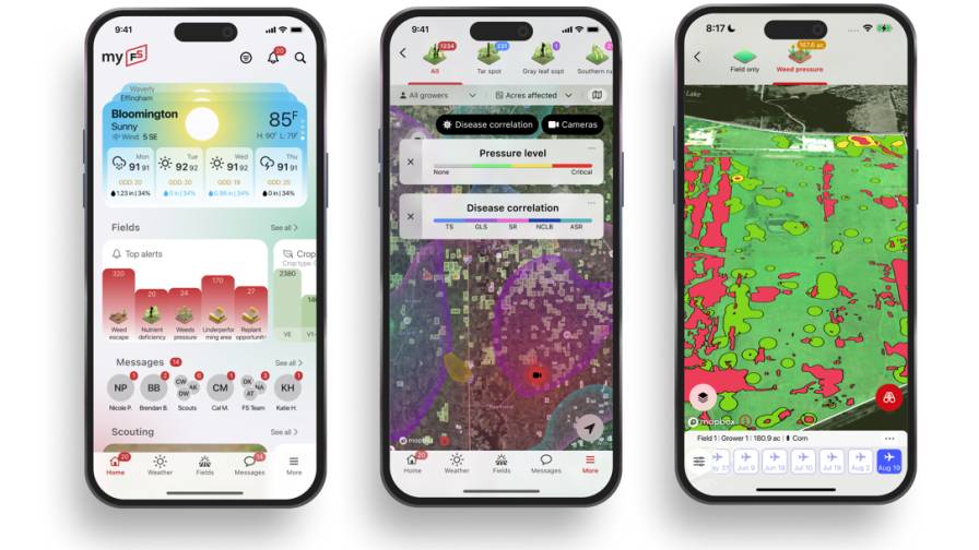
Pix4D: What map is the most valuable to you and your clients?
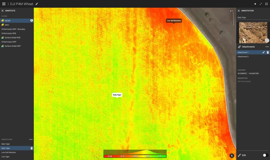
Guadagnoli: The NDVI and NDRE index maps are very useful to start because these allow you to see issues invisible to the naked eye. The zonation step after you’ve generated these maps is even better because that allows you to make your data actionable. Data for the sake of data is interesting but being able to take action from that data is where the value comes from.
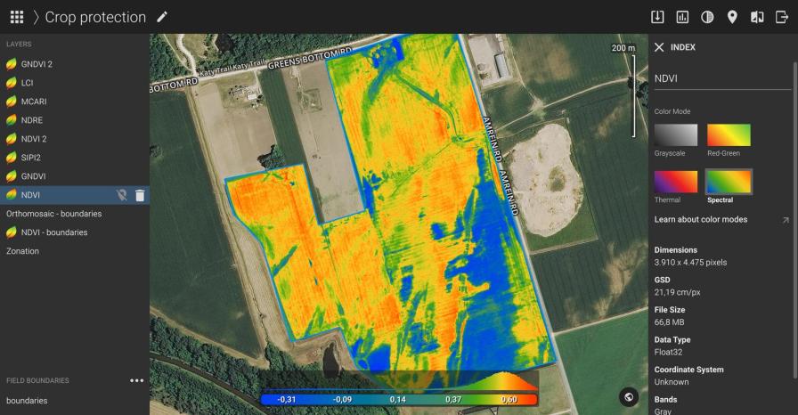
NDVI index maps can highlight problem areas invisible to the naked eye.
Pix4D: What are you looking for when doing the analysis?
Guadagnoli: Problem areas that were not already known to the grower, such as stressed crops. Knowing the crop is stressed allows you to work with the grower on the next step, which is why is the crop stressed? Is it too little or too much water? Insect attacks? Fungus or mold? Once you know the problem you’re dealing with, you can begin to formulate a strategy to mitigate the issue.
Pix4D: What type of output in-field do you anticipate using most?
Guadagnoli: Viewing the map at the field’s edge with the grower and their agronomist will be key, as you can immediately spot stressed areas of the field that you can then walk to and investigate further.
Digital Scouting
Pix4D: How can a map help your customers scout?
Guadagnoli: Having the map arms the customer with visual cues as to where issues may lie in their fields. They don’t have to blindly walk their rows to identify issues with their eyes, the map saves them a lot of time and effort in giving them targets they need to check out further.
Pix4D: How do the findings of scouting post-in-field analysis compare to the traditional ‘blind’ scouting?
Guadagnoli: This is a massive time savings for the customer in that they don’t have to wander their fields aimlessly in hopes of finding issues – you can take a rifle approach to your fields, rather than a shotgun approach. The birds-eye view of the drone spots issues, Pix4Dfields clearly shows them the hot spots to check out, and then they can walk directly to the problem areas feeling secure they’ve identified them all from the sky.
Pix4Dfields clearly shows hot spots to check out.
Actionable Results (Variable Rate Application)
Pix4D: Why is it important to be able to create a zonation map in the field?
Guadagnoli: It’s a strong demo tool to advocate for the NDVI and NDRE maps, in that once the zones are established you can show the customer that by adjusting the application rate of the product in those zones instead of one flat rate application, simple math on a notebook can show the customer how much money can be saved by using variable rate technology to adjust rates in each zone. This shows the customer how the UAS can help deliver more money to their pocket instead of paying it out needlessly to over-apply the product in certain zones.
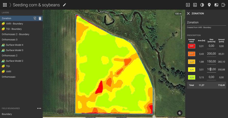
Zonation maps allow growers to target application rates.
Result-Based Decision Making
Pix4D: How do your customers use the John Deere Operations Center on their farms?
Guadagnoli: It’s used by growers:
- To assimilate all their data sources into one platform.
- To archive prior season’s data such as planting rates and yield rates.
- To collect all the information about the product and seed varieties such as cost, name, EPA registration number and where different varieties are planted in their fields.
- To generate prescriptions and pass those prescriptions to their machines.
- To collate documentation from all their different applications throughout the season such as tillage, planting, application, and harvest.
- To keep on top of their machine’s health and location via the John Deere Link connection into Operations Center.
Pix4D: What is the benefit of integrating Pix4Dfields maps into the John Deere Operations Center?
Guadagnoli: It gives the growers what they want, in a single farm management platform to aggregate all their data in one place. It also provides a very seamless flow of data from collection to action based on the data collected to machines such as sprayers.
Pix4D: With data in the John Deere Operations Center, what can your customers do now that they couldn’t before?
Guadagnoli: It allows them to achieve the same or better results as they could before, in a much more efficient way. It removes the need for separate software platforms to achieve the end result, as it can all be done through Pix4Dfields and Operations Center’s integration. It also eliminates mistakes caused by handwritten documentation or hand-sketched maps, which can lead to costly crop destruction due to under or over-application of the product.
Importing Pix4Dfields data into the John Deere Operations Center unlocks new possibilities.
Pix4D: Is there an app for the Operations Center and what does it enable?
Guadagnoli: MyOps is an app that runs on iOS or Android, which gives the grower access to much of the functionality available in the web browser-based edition of Operations Center.
An Integration That Saves Time
Pix4D: How does a product like Pix4Dfields help you be a better dealer?
Guadagnoli: It gives us the ability to provide solutions to our producers that truly improves their quality of life, which is very important to us. Our tagline is “Your Working Partner” and we take that seriously and are always looking for solutions that will truly bring value to our customers. Pix4Dfields along with the integration to Operations Center brings evidence to our customers that we’re delivering on that promise by working to bring them solutions that will give them back more time with their families.
Subscribe Today For
